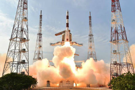
The Indian Space Research Organisation (ISRO) has successfully launched the PSLV-C41/IRNSS-1I. IRNSS-1I is a navigation satellite and the eighth satellite in the constellation. The PSLV-C41/IRNSS-1I Mission kicked off at 04:04 AM IST on Thursday.
ISRO IRNSS NavIC launch
The launch was ISRO’s second endeavour at sending a replacement satellite. The earlier mission of a PSLV carrying IRNSS-1H in August last year failed after the heat shield covering the satellite failed to separate.
This also comes two weeks after the space agency launched GSAT-6A on board GSLV Mk-II but the rocket placed GSAT-6A in orbit, ISRO lost communication with the satellite.
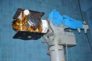
irnss-1i undergoing catf test Source :ISRO
RNSS-1I is expected to replace IRNSS-1A, the first of the seven navigation satellites that became dysfunctional after its three rubidium atomic clocks failed. The seven satellites are part of the NavIC navigation satellite constellation.
Previously, the Space Agency said, “India’s Polar Satellite Launch Vehicle, in its forty-third flight (PSLV-C41) in XL configuration will launch IRNSS-1I Satellite from First Launch Pad (FLP) of SDSC (Satish Dhawan Space Centre), Sriharikota.”
The ‘XL’ configuration of PSLV is used for the twentieth time. The IRNSS-1I is the eighth satellite to join the NavIC navigation satellite constellation, ISRO added.
Top facts about Navic Desi GPS
- This is the second attempt by ISRO to send a replacement satellite as on August 2017 the launch of IRNSS-1H failed.
- NavIC’s first satellite, IRNSS-1A, was launched in July 2013. Three years into what was expected to be a ten-year mission, one of the three atomic clocks aboard the satellite failed. The spacecraft’s other two clocks failed over the next six months, leaving it unable to broadcast navigation data.
- This system was commissioned in 2006. One of its main aims is to help the military in hostile situations as foreign countries may not help with their navigation systems in such times. The purpose of these IRNSS satellites is to create India’s own navigation system which would be in the lines of US’ GPS or Global Positioning System.
- On the Comptroller and Auditor General (CAG) being critical of NavIC still not being fully operational, after more than 10 years of its launch, the ISRO head said with the launch of IRNSS-1I, the system was now put in place and the applications would have to be rolled out.
- Serving both military and civilian needs, NavIC relies on seven satellites broadcasting highly-accurate timing signals that a receiver can use to triangulate its location.
- Three of NavIC’s satellites are positioned in equatorial geostationary orbits, while the remaining four satellites are in geosynchronous orbits inclined by about 28 degrees to the equator.
- Built for a ten-year job in space, IRNSS-1I is expected to be ready for work in about a month after routine orbit manoeuvres and tests.
- NavIC provides two types of services — standard positioning service for all users; and restricted service which will be an encrypted service for only authorised users.
- The navigation system is also helpful for railways in tracking trains and also giving an alert in the case of an unmanned level crossing.
- Till now, PSLV has successfully launched 52 Indian satellites and 237 customer satellites from abroad.
- In the road transport sector, NavIC helps commuters to traverse distances and also enables transport operators to track their vehicles.